Leon
City and Local Maps
Click
on a thumbnail image to view a full size version of that map.
| 
|
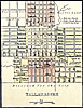
Tallahassee, 1850. Detail inset from a state map.
|
| 
|
Bloxham, Holland, and surrounding area, 1940. Detail from a Florida highway map.
|
| 
|
Bradfordville and surrounding area, 1940. Detail from a Florida highway map.
|
| 
|
Chaires and surrounding area, 1940. Detail from a Florida highway map.
|
| 
|
Iamonia and surrounding area, 1940. Detail from a Florida highway map.
|
| 
|
Lake Jackson and surrounding area, 1940. Detail from a Florida highway map.
|
| 
|
Meridian and surrounding area, 1940. Detail from a Florida highway map.
|
| 
|
Miccosukee and surrounding area, 1940. Detail from a Florida highway map.
|
| 
|
Natural Bridge and surrounding area, 1940. Detail from a Florida highway map.
|
| 
|
Wadesboro and surrounding area, 1940. Detail from a Florida highway map.
|
| 
|
Woodville and surrounding area, 1940. Detail from a Florida highway map.
|
Exploring
Florida: A Social Studies Resource for Students and Teachers
Produced by the Florida Center for Instructional
Technology,
College of Education, University of South Florida © 2002.